Previous slide
Next slide
Deep Geo Survey
WE MAKE EARTH'S CRUST TRANSPARENT!
Absolutely! Our revolutionary method relies solely on cutting-edge satellite image analysis, providing precise locations of oil, gas, and valuable minerals without any physical presence required.
Fear not! Our remote prospecting eliminates the need for wildcat drillings, excavating, or seismic analysis, delivering instant and accurate results right to your fingertips.
There are no limits to the use of our technology! We can remotely screen any place in the world onshore and offshore at any required depth, unveiling the hidden treasures beneath the surface.
Contact us today to embark on a journey of successful exploration!
Deep Geo Survey
Full range of services for mineral deposits exploration
MINERAL DEPOSITS EXPLORATION
- Fossil fuels: oil, gas, gas condensate, gas hydrate.
- Ore: gold, copper, zinc, uranium, etc.
- Water: drinking, mineralized; natural and man-made water flows.
ANALYSIS OF SPACE IMAGES
- Express method for minerals deposits mapping.
- Analysis of large areas.
- Analysis of hard-to-reach places.
PRECISE WELL ANALYSIS
- Approximate chemical composition of deposits.
- Estimation of the amount of deposits available for extraction.
- Determining the optimal location of wells.
Deep Geo Survey
Frequency-Resonance Survey Technology
Today, we introduce a pioneering method for geological exploration, leveraging concepts initially postulated by Nikola Tesla about energy, vibrations, and frequencies. This method, known as the Frequency-Resonance Survey (FRS), utilizes unique vibrational signatures, or “fingerprints,” of elements, minerals, and chemical substances to decode hidden geological information from photographic images of the Earth’s surface, enabling unprecedented accuracy and depth in subsurface exploration.
Fundamental Principles
- Unique Vibrational Signatures: Each element, mineral, and chemical compound possesses an intrinsic vibrational frequency that serves as its unique identifier. These frequencies are cataloged extensively in our proprietary databases and are critical to the FRS method.
- Photographic Frequency Mapping: Every photographic image of the Earth’s surface captures a spectrum that is a composite of all frequencies emitted from elements and compounds within the Earth’s crust. This spectrum includes visible light and extends into other frequency ranges, which are detectable with advanced photographic and satellite technology.
Basics of Frequency-Resonance Processing and Getting Results
Using high-resolution satellite and photographic imagery, we employ electronic devices and spectral analyzers, supported by sophisticated software algorithms, to compare known spectral fingerprints of chemical elements with those in images. This process identifies frequency resonances that confirm the presence or absence of specific minerals, elements, and chemical substances within the target area. After recording the basic frequency-resonance and thus detecting the searched element in the image, we employ a secondary part of analysis by estimating the three-dimensional distribution of harmonic resonances, enabling precise estimation of the coordinates of subsurface deposits of searched minerals.
Enhanced Methodology
- High-Resolution Capabilities and Precision Analysis: Our technology achieves resolutions as precise as 1 cm and explores geological formations up to 15 km deep—far beyond the reach of conventional drilling technologies. This precision allows for an accurate determination of both the depth and extent of subsurface layers, providing crucial data for strategic planning and minimizing exploratory risks.
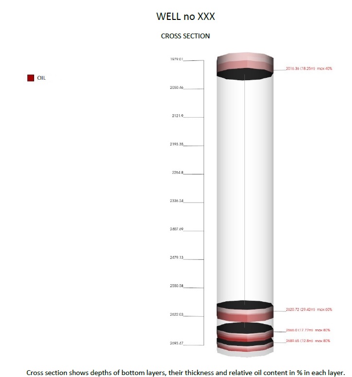
- Three-Dimensional Mapping: The FRS technology enables the creation of detailed three-dimensional maps of subsoil resources. For areas of interest, a virtual borehole can be simulated, which allows for precise vertical scanning and mapping without the need for physical drilling.
- Operational Efficiency through Remote Sensing: The FRS technology enables remote operations, allowing comprehensive geological assessments from afar. This capability not only speeds up the exploration process but also circumvents the logistical challenges and high costs associated with physical site surveys, making it ideal for exploring inaccessible or remote areas.
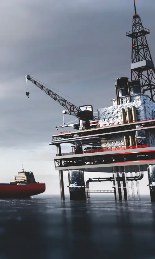
Offshore Applications
The FRS method is equally effective offshore. In marine environments, our technology demonstrates that water does not significantly alter the spectral data. This robustness allows the frequency readings to remain unaffected by the water layers, ensuring that the spectral data transmitted to the surface is a reliable reflection of the subsurface geological formations. As a result, the FRS technology can effectively replace traditional 2D and 3D underwater seismic surveys, providing precise and undistorted data for offshore explorations.
Stages of the Survey
- Stage 1: Reconnaissance: Processing of satellite images of a given area to determine the presence or absence of desired minerals or elements. This initial stage is crucial for quick identification of areas with potential resources, guiding further detailed analysis.
- Stage 2: Integral: Processing to identify existing layers or strata, their depths, and thickness in the surveyed area. This stage deepens the understanding of the geological framework, enabling accurate mapping of the subsurface structure.
- Stage 3: Detailed: Detailed processing to identify the most promising local blocks, identified at the previous integral stage, in order to select sites for drilling of prospecting and exploration wells. This final stage focuses on pinpointing precise locations for resource extraction, optimizing the exploration efforts and resources.
Applications and Benefits
- Resource Identification: FRS technology can precisely locate and identify geological strata, including oil and gas deposits, metal ores, and underground water reserves. This capability is invaluable for strategic planning and operational decisions in the oil and gas industry.
- Cost-Effectiveness: By reducing the need for exploratory drilling and seismic methods, FRS technology significantly cuts operational costs and accelerates the exploration process. The ability to conduct remote surveys and create virtual boreholes can save millions in drilling and development costs.
- Strategic Advantages: Utilizing satellite-based technology allows for unrestricted access to exploration sites worldwide without the need for landowner consent or navigation through jurisdictional limitations. This global operational capability provides a unique competitive advantage, making FRS technology indispensable for the extraction industry.
- Environmental Advantages: With its non-invasive nature, FRS technology minimizes the environmental footprint associated with traditional exploration techniques. This is particularly crucial in sensitive or protected areas, where physical exploration may be restricted or contested.
Conclusion
The Frequency-Resonance Survey (FRS) technology represents a quantum leap in the field of geological exploration. By harnessing the unique vibrational signatures of subterranean elements and compounds, this method offers a highly accurate, cost-effective, and environmentally friendly alternative to traditional exploration methods. As we continue to refine and expand the capabilities of FRS, we invite stakeholders and decision-makers in the oil and gas industry to join us in realizing the full potential of this transformative technology. Our unique remote sensing technology decodes complex geological structures and detects valuable resource deposits anywhere and at any depth, providing invaluable information for exploration and extraction projects worldwide.
Remote Exploration of Oil, Gas, Metal Ores, Minerals, Elements, and Water Resources
Our groundbreaking, globally unique method is based on the development and practical application of Nikola Tesla’s theory on detecting standing electric waves generated in deep layers of the Earth’s crust. This innovative technology assigns a unique frequency (“fingerprint”) to each element, mineral, or chemical compound and decodes hidden information from photographic images of a specific surface area. Our approach offers unparalleled accuracy in remote exploration of any mineral on land and at sea, providing valuable insights for the oil and gas industry.
Our technology employs frequency-resonance scanning of high-resolution satellite images and photographs’ informational content using specially designed electronic devices and advanced computer algorithms. Sophisticated comparative analysis of spectral signatures from targeted geological formations with rock, mineral, and chemical element samples facilitates the detection of subsurface structures and potential hydrocarbon reservoirs. The method allows for vertical scanning of planned drilling locations up to a depth of 10 km with high accuracy, providing a three-dimensional resource map.
- Remote Operation: Our method eliminates the need for physical presence on-site, enabling accelerated assessment of oil, gas, mineral, metal ore, and water resources in any exploration area worldwide.
- High Accuracy: Our frequency-resonance method achieves a level of accuracy unattainable by conventional geological methods, enabling precise determination of depth and extent of the studied geological layers.
- Versatility: The technology is effective on both land and marine areas, as water carries signals, allowing deep penetration of oil and gas resources in any continental shelf.
- Cost-Effectiveness: Access to this information in advance can assist in making informed decisions before entering contracts or initiating costly drilling operations, saving money and avoiding unnecessary expenditures.
- Unrestricted Access: Scanning of investigated areas does not require knowledge or consent of landowners, as no country’s jurisdiction extends to outer space. Based on high-resolution satellite images, we can examine any location for the presence of hydrocarbons and other minerals, providing a unique advantage for investors. There is no effective protection against such scanning.
- Exploratory Research: Surface frequency-resonance analysis of satellite images covering extensive land and marine areas to determine the presence of individual minerals or layers containing hydrocarbons or other minerals on the studied surface.
- Extraction Research: In-depth frequency-resonance analysis of satellite images and photographs for specific locations (areas), facilitating precise determination of mineral deposits or other minerals and, based on this, pinpointing optimal extraction sites.
Our unique remote sensing technology offers an innovative way to decode complex geological structures and detect valuable resource deposits in the oil and gas industry, anywhere and at any depth. Utilizing the principle of frequency resonance, we provide invaluable information for exploration and extraction projects, ultimately saving time and resources for investors and oil companies. Unrestricted access to locations worldwide guarantees a competitive advantage, making this technology indispensable for every extraction industry and providing governments with comprehensive knowledge of their resource assets unattainable by any other method.
Deep Geo Survey
How we work?
Our technology employs frequency-resonance scanning of high-resolution satellite images and photographs’ informational content using specially designed electronic devices and advanced computer algorithms. Sophisticated comparative analysis of spectral signatures from targeted geological formations with rock, mineral, and chemical element samples facilitates the detection of subsurface structures and potential hydrocarbon reservoirs. The method allows for vertical scanning of planned drilling locations up to a depth of 10 km with high accuracy, providing a three-dimensional resource map.

We design one technological solution for the complex needs of the Client
Deep Geo Survey
Why you should work with us?
High accuracy of the obtained data with a clear indication of the location of minerals on the maps and high step detailing in meters.
Processing of large areas using the technology of analysis of space images allows to obtain results for the presence of minerals in a short time.
Application of frequency – resonance technology for surveying hard-to-reach areas, onshore and offshore as well.
The use of technology in the survey of large areas and guarantee the productivity of the found wells can save a lot of money.
in the field of mobile direct exploration technologies (geoelectric and frequency resonance methods for processing and decoding satellite images and photographs) for the search and exploration of ores and combustible minerals and the assessment of mining prospects